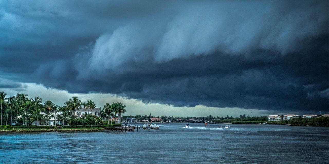
Hurricane what is it? You might not know that hurricanes can sometimes generate waves taller than 50 feet. These powerful tropical cyclones form over warm ocean waters, primarily in the Atlantic basin, Caribbean Sea, and Gulf of Mexico, and their season runs from June 1 to November 30. As a skipper offering yacht delivery service I know, avoiding these destructive storms requires more than just luck; it demands vigilance and a solid understanding of specific navigation rules. Have you ever considered how closely monitoring the National Hurricane Center’s updates and adhering to the 34-kt and Mariners 1-2-3 Rules could be your key to safety?

| Season duration | June 1 through November 30 |
| Peak activity period | Late August through September, with a midpoint on September 10 |
| Naming | Tropical and subtropical cyclones reaching tropical storm intensity are named from a pre-determined list |
| Average number of storms | 10.1 named storms, 5.9 becoming hurricanes, and 2.5 becoming major hurricanes (Category 3 or higher) |
| Most active season | 2020 with 30 named tropical cyclones |
| Most hurricanes in a season | 2005 season with 15 hurricanes |
| Least active season | 1914 with only one known tropical cyclone |
Definition of a Hurricane
A hurricane, defined scientifically as a tropical cyclone, is a rotating low-pressure system with organized thunderstorms, forming over tropical or subtropical waters without any frontal boundaries. It’s a complex meteorological phenomena that develop primarily in the Atlantic Ocean. But these systems aren’t just random occurrences; they follow precise atmospheric conditions.
A hurricane begins as a tropical disturbance, evolving into a tropical depression with winds less than 39 mph. It then escalates into a tropical storm with wind speeds ranging from 39 to 73 mph. This critical phase is where the storm gains energy and its structure becomes more organized. When the winds exceed 74 mph, it’s officially classified as a hurricane.
Understanding the nature of these tropical systems is essential, especially for those sailing the Atlantic during hurricane season, which spans from June 1 to November 30. During this period, the warm waters of the Atlantic provide the necessary heat and moisture, fueling these powerful storms.
Hurricane Categories

Hurricanes are categorized using the Saffir-Simpson Hurricane Wind Scale, which measures maximum sustained winds to classify storms from Category 1 (weakest) to Category 5 (strongest). This scale is fundamental in determining the potential damage a hurricane can inflict.
A Category 1 hurricane, with winds ranging from 74-95 mph, can cause some damage to homes and trees. A Category 2, with winds from 96-110 mph, can result in extensive property damage. Categories 3, 4, and 5, with winds exceeding 111 mph, can cause devastating to catastrophic damage, respectively. These higher categories often lead to severe structural damage and widespread power outages.
The Saffir-Simpson scale isn’t just about numbers; it provides a critical framework for accurate forecasts and warnings. NOAA’s National Hurricane Center utilizes these hurricane categories to communicate the storm’s severity and potential impact effectively.
Hurricane Origins

Hurricanes originate in the Atlantic basin, including the Atlantic Ocean, Caribbean Sea, and Gulf of Mexico in Pacific Ocean, where warm ocean waters and specific atmospheric conditions converge to fuel their development. You’ll also find them forming in the eastern North Pacific Ocean and occasionally in the central North Pacific Ocean.
The genesis of hurricanes is a complex process involving the interaction of warm ocean waters, which must be at least 26.5°C (80°F), and atmospheric conditions such as low vertical wind shear and sufficient moisture in the mid-troposphere.
When these conditions align, clusters of thunderstorms can organize into a cyclonic system. The latent heat released from condensation in these thunderstorms further warms the air, decreasing surface pressure and promoting more rapid rotation and intensification of the system.
Meteorological data and advanced modeling techniques allow scientists to track these storms from their inception, giving you and other sailors information to navigate safely. Just be prepared to get them in time and when received too late you have to know what to do to minimize the risk of meeting The Beast.
Hurricane Season
Eastern Pacific Hurricane Season: May 15-November 30.
Atlantic Hurricane Season: June 1-November 30.
Central Pacific Hurricane Season: June 1-November 30.
The Atlantic hurricane season runs from June 1 to November 30, with peak activity typically occurring from late August through September. On average, there are about 14 named storms, 7 hurricanes, and 3 major hurricanes each season, based on a 30-year climate period from 1991 to 2020.
Monitoring updates from NOAA’s National Hurricane Center can provide critical data for safety and preparedness.
Peak Activity Periods
In the Atlantic basin, the peak activity period for hurricanes generally spans from late August to September, a time when meteorologists observe the highest frequency and intensity of storm development. This period is particularly important for understanding tropical cyclone development and evaluating potential landfall threats. During these months, the conditions in the Atlantic basin—such as sea surface temperatures, atmospheric moisture, and wind patterns—are ideal for hurricane formation and intensification.
| Period | Activity Level |
| June – July | Low |
| Late August | Peak |
| September | Peak |
| October – November | Decreasing |
| December – April | Very Low – but NEVER NONE |
Understanding peak activity periods allows you to better prepare and plan your sailing routes. Here’s a table to illustrate the peak activity period:
Annual Hurricane Count
It’s important to recognize that the official Hurricane Season spans from June 1 to November 30, with an average of about 12 hurricanes forming annually in the Atlantic basin. This timeframe is critical for sailors, as the NOAA’s National Hurricane Center (NHC) actively predicts and tracks these storms to provide timely warnings and updates.
| Month | Average Named Storms | Average Hurricanes | Average Major Hurricanes |
| January | 0.1 | 0 | 0 |
| February | 0.03 | 0 | 0 |
| March | 0.03 | 0 | 0 |
| April | 0.03 | 0 | 0 |
| May | 0.1 | 0 | 0 |
| June | 3 | 0.5 | 0 |
| July | 5 | 1 | 0.5 |
| August | 8 | 3 | 1 |
| September | 10 | 4 | 1.5 |
| October | 8 | 2 | 0.5 |
| November | 3 | 0.5 | 0 |
| December | 0.1 | 0 | 0 |
Understanding the annual count of hurricanes is essential for evaluating the potential impact on maritime activities. By analyzing historical data, the NHC has established that the majority of hurricanes cluster within this six-month period, although outliers can occur outside this window.
Precise tracking and prediction models employed by the NHC allow for a better understanding of storm development, which in turn, aids in formulating strategies to mitigate risks. As a sailor, staying updated with these forecasts can notably enhance your preparedness and safety.
Record Hurricane Seasons
The most active hurricane season on record was just few years ago, in 2020, which saw 30 named tropical cyclones. However, the record for the most hurricanes (15) was set in 2005. These years highlight the variability in hurricane activity and the increasing trends observed in recent decades.
Hurricane Preparedness
Atlantic basin faces an average of 12 hurricanes each season. The National Hurricane Center, a key division of NOAA, plays a vital role in predicting and tracking these formidable storms. During hurricane season, which stretches from June 1 to November 30, AND OUT OF THIS SEASON, as well, being prepared can greatly reduce potential damage and save lives.
Hurricane preparedness involves thorough planning and resource allocation, emphasizing the protection of people, property, and natural resources. If you are catched in the port Ready.gov provides extensive guidelines to help individuals and communities enhance their readiness. These preparations include creating an emergency kit, developing a family communication plan, and understanding local surviving tactics.
To aid in your preparedness efforts, consider the following essential resources:
| Resource | Description | Website |
| National Hurricane Center | Tracks and predicts hurricanes | nhc.noaa.gov |
| Ready.gov | Hurricane preparedness resources | ready.gov |
| NOAA | Weather updates and forecasts | noaa.gov |
Typical Paths of Hurricanes
Hurricanes typically originate in the tropical Atlantic and Pacific, moving westward due to the influence of the subtropical ridge, a high-pressure system. As they progress, they may turn northward and recurve toward the northeast, influenced by upper-level winds and pressure systems.

- Tracking of hurricane Fiona 2022 from Coast.NOAA.com
Unusual Hurricane Paths and Out-of-Season Activity
Hurricanes can occasionally take atypical paths or form outside the traditional season:
Unusual Path Example: Hurricane Sandy in 2012 is a notable example; it made an unexpected left turn toward the U.S. East Coast, causing significant damage in New Jersey and New York.
Out-of-Season Example: Tropical Storm Ana formed in May 2021, prior to the official start of the hurricane season, demonstrating that tropical cyclones can develop outside the typical June to November timeframe.

Sample of untypical paths and time from National Hurricane Center
Study these patterns and trends carefully to before planning to cross the Atlantic, as they can significantly impact safety and navigation.
Hurricane Naming
Each hurricane name is selected from lists curated by the World Meteorological Organization, with significant storms retiring to avoid future confusion. These lists rotate annually within each oceanic basin, ensuring systematic and organized identification of storms.
Naming Conventions Explained
The World Meteorological Organization (WMO) meticulously manages the naming of hurricanes using a series of predetermined lists specific to various oceanic basins. By maintaining rotating lists, the WMO ensures that hurricane names are recycled every six years. This system aids in tracking and distinguishing individual storms, making communication clearer and more efficient.
Hurricane names are retired if the storms cause significant damage or casualties, thereby preventing future use out of respect for the affected communities. In the Atlantic basin alone, 83 names have been retired, including infamous ones like Katrina, Andrew, and Mitch. These retired names serve as poignant reminders of the storms’ lasting impacts.
Various basins have their own naming practices, reflecting the diverse regions affected by hurricanes. The WMO’s systematic approach guarantees consistency across these regions, thereby enhancing the efficiency of meteorological communication.
| Basin | Number of Retired Names | Example of Retired Name | Naming Cycle (Years) | First Use of Current List |
| Atlantic | 83 | Katrina | 6 | 2023 |
| Eastern Pacific | 42 | Patricia | 6 | 2022 |
| Western Pacific | 15 | Haiyan | 4 | 2021 |
| Northern Indian Ocean | 10 | Phailin | 3 | 2020 |
| Southern Hemisphere | 25 | Winston | 5 | 2019 |
Navigation Rules
In collaboration with mariners, the National Hurricane Center has developed essential navigation rules like the 34-kt Rule and Mariners 1-2-3 Rule to guarantee safe passage during hurricanes. The 34-kt Rule is designed to help you avoid the wind field of a hurricane, ensuring your vessel remains maneuverable in challenging conditions. By steering clear of zones where wind speeds exceed 34 knots, you can maintain better control and reduce the risk of damage or capsize. Easy to say, right? 🙂
The Mariners 1-2-3 Rule, on the other hand, expands the forecasted danger zone around the hurricane by 100 nautical miles (nm) per day, accounting for the inherent uncertainties in predicting hurricane tracks. This rule is essential for navigation safety, as historical forecast errors are factored in to create a more extensive safety buffer.
1-2-3 RULE:
1 – 100 mile error radius for 24hr forecast
2 – 200 mile error radius for 48hr forecast
3 – 300 mile error radius for 72hr forecast
Influence of Global Warming
Research indicates that global warming is impacting hurricane activity in several ways:
- Increased Intensity: Warmer ocean temperatures can lead to stronger hurricanes, as they provide more energy for storm development.
- More Frequent Hurricanes: While the overall number of hurricanes may not significantly increase, there is a trend toward more intense storms, with a higher proportion reaching major hurricane status.
- Changes in Path: Climate change may alter atmospheric patterns, potentially leading to hurricanes following unusual paths or making landfall in unexpected locations.
Wind against currents – Navigating the Gulf Stream’s Challenges
When you’re sailing near the Gulf Stream, keep in mind how it can affect sea conditions. One major issue is how the current interacts with the winds from tropical storms or hurricanes. When strong winds blow against the Gulf Stream, they can whip up steep, short waves that make for a rough ride.These waves can come on quickly, turning calm waters into a chaotic mess. This can make steering your vessel a real challenge and increase the risk of losing control.If you find yourself in these waters during a storm, be ready for tough conditions. It’s wise to adjust your course or seek a safer harbor if things start to get dicey. Always prioritize safety and stay alert to the changing environment around you. Let me know if you need any more tweaks or additional content! Check blog about Gulf Stream


