
Weather Forecast Models for Sailors
Imagine you’re a sailor planning a voyage across the Atlantic, and you rely on the ECMWF model for its high-resolution forecasts near coastlines. But have you considered how regional models like WRF8 might offer even more precise data for specific areas? Accurate weather forecasts are important for safety and route planning.. Understanding the strengths and limitations of different models can make all the difference in your journey. Curious about which weather apps can provide the best insights for sailors?
Our skippers from company offering yacht delivery service know what, when and to check to move Customer’s boats on time and in one piece. Let us share this secret knowledge below 🙂
Overview of Weather Models
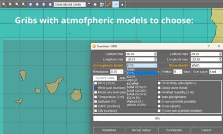
Weather forecast models, such as ECMWF and GFS, are important tools for sailors to predict wind patterns, wave heights, and atmospheric pressure changes. These forecast models divide the Earth into a grid of boxes to approximate current conditions and forecast future weather. This grid-based structure is used for generating accurate Medium-Range Weather Forecasts, typically extending from three to ten days ahead.
The ECMWF (European Centre for Medium-Range Weather Forecasts) offers a spatial resolution of 9km, providing highly detailed wind forecasts and atmospheric data. Meanwhile, the global forecast model GFS (Global Forecast System) operates at a 27km resolution. While both models are valuable, ECMWF’s finer spatial resolution often results in more precise predictions, especially for wind forecasts for sailing.
Understanding the limitations and strengths of these models is very important. The accuracy of these forecast models is influenced by both spatial and temporal factors, impacting the precision of your navigational decisions. By integrating data from these global forecast models into your voyage planning, you can build your weather routing strategies.
Importance of Accurate Forecasts
Precise weather predictions is vital for sailors to plan safe and efficient routes, mitigating the risks posed by severe weather conditions. Reliable forecasts allow you to navigate with a clear understanding of wind and wave patterns, which is essential for maximizing sailing efficiency and ensuring the safety of both crew and vessel.
Interpreting weather conditions requires understanding intricate variables like wind speed, air pressure systems, and precipitation. For instance, knowing when a low-pressure system is approaching can help you prepare for potential storms, while high-pressure systems could signal calmer seas. Accurate forecasts enable you to avoid hazardous areas, thereby reducing the risk of accidents and mechanical failures.
Moreover, local weather phenomena and temperature fluctuations greatly impact forecast accuracy. Regularly updating your knowledge through workshops and advice from experienced sailors enhances your ability to interpret these forecasts. This continuous learning fosters a sense of belonging within the sailing community, reinforcing shared commitment to safety and efficiency.
Comparison of Weather Forecast Models for Sailing
| Weather Model | Resolution | Update Frequency | Best For | Limitations | Source/Authority |
|---|---|---|---|---|---|
| ECMWF (European Centre for Medium-Range Weather Forecasts) | 9 km | Twice daily | Long-range, high-precision forecasts, especially useful near coastlines | Fewer updates compared to GFS | ECMWF Official Site |
| GFS (Global Forecast System) | 27 km | Four times daily | Global-scale, frequently updated forecasts | Lower resolution, less detail near coastlines | NOAA GFS Information |
| ICON7 (by DWD – German Weather Service) | 7 km | Twice daily | High-resolution, regional forecasts for Europe | Limited global coverage | DWD Official Site |
| WRF8 (Weather Research and Forecasting Model) | 8 km | Variable, short-to-medium range | Regional and local forecasts; good for complex terrain and coastal areas | Limited long-term prediction capability | WRF Model Overview |
| NAM (North American Mesoscale Model) | 12 km | Four times daily | North America-focused; good mesoscale details for local weather phenomena | Limited global coverage, longer-term predictions weaker | NOAA NAM Overview |
| HRRR (High-Resolution Rapid Refresh) | 3 km | Hourly | Near real-time updates, good for rapidly changing conditions | Only covers the US and regions nearby | HRRR Model Information |
| AROME (by Météo-France) | 1.3 km | Every 6 hours | Ultra-high resolution for short-term, local forecasts; great for specific maritime zones | Limited regional availability | Météo-France AROME |
SHort notes::
- ECMWF offers the highest resolution for global, long-term forecasting, making it ideal for route planning across large seas and regions.
- GFS excels with frequent updates, providing broad weather patterns across the globe but lacks the detailed accuracy in complex coastal regions.
- ICON7 and WRF8 are standout models for regional forecasting, offering detailed insights in specific areas, especially in Europe and North America, respectively.
- HRRR is indispensable for sailors requiring frequent updates for short-term decisions, especially useful in unpredictable conditions, though its coverage is limited to North America.
- AROME provides the finest spatial resolution, which is incredibly useful for short-term weather routing and localized predictions in areas like the Mediterranean.
Global Models: GFS and ECMWF
When checking global weather models for sailing, you’ll find that the GFS has a 27km resolution and updates four times daily, whereas the ECMWF offers a 9km resolution with updates twice daily.
The ECMWF’s higher resolution contributes to its superior accuracy, especially near coastlines where GFS may falter.
For precise and reliable forecasts, ECMWF’s detailed predictions often make it the favored choice among sailors.
Resolution and Update Frequency
Leveraging high-definition and frequent updates, global weather models like GFS and ECMWF are essential tools for sailors seeking accurate and timely forecasts. The resolution of these models is a vital factor in determining the level of detail and precision in weather forecasting.
The GFS model, with a resolution of 27km, updates four times daily. This update frequency allows it to provide broad-scale weather predictions, making it valuable for sailors needing timely updates. However, its resolution mightn’t capture intricate topographical details, particularly near coastal regions.
On the other hand, the ECMWF model boasts a higher resolution of 9km and updates twice daily. Despite its lower update frequency compared to GFS, ECMWF is widely regarded as the most accurate global model. Its high resolution allows for more precise and reliable forecasts, which are essential for sailors planning their routes and ensuring safety at sea.
Both models serve an important role in weather forecasting for sailors. The choice between them often depends on the need for higher resolution versus more frequent updates. Ultimately, understanding the strengths of each model allows sailors to make informed decisions and navigate safely.
Accuracy and Regional Focus
Precision and regional focus in global weather models like GFS and ECMWF are essential for sailors who rely on accurate and dependable forecasts for safe navigation. When you’re planning a voyage, understanding the precision and spatial resolution of these models can greatly impact your weather predictions.
The Global Forecast System (GFS) operates at a spatial resolution of 27km and is updated four times daily. While GFS provides extensive global coverage, it can lack detailed topography near coastal regions, which might be pivotal for your navigation needs.
On the other hand, the European Centre for Medium-Range Weather Forecasts (ECMWF) model stands out with a higher spatial resolution of 9km and is updated twice daily. This increased resolution enhances forecast precision, making ECMWF a preferred choice for sailors seeking accurate weather data.
Both models cover different regions with varying levels of detail, so selecting between GFS and ECMWF depends on your specific sailing area and the detail required for your forecasts.
For high-stakes voyage planning, the superior regional focus and precision of ECMWF can provide you with the reliable data needed to guarantee safety and optimize route decisions, even in complex coastal environments.
Regional Models for Sailing
You’ll find that regional weather models like ICON7, WRF8, NAM, and HRRR are indispensable for sailors seeking high-resolution, region-specific forecasts. These models enable precise weather routing by providing detailed data on wind speed and direction, sea state, and wave forecasts. For instance, the ICON7 model offers a spatial resolution of 7km in European waters, making it a valuable tool for charting complex marine environments. Engaging with your Marine Weather Center can further enhance your understanding of these forecasts, ensuring you’re well-prepared for any weather changes.
WRF8, NAM, and HRRR models also deliver critical insights. WRF8 (Weather Research and Forecasting Model) is particularly effective for short-to-medium-range predictions, while NAM (North American Mesoscale) provides extensive coverage across North America with a focus on mesoscale meteorological phenomena. The HRRR (High-Resolution Rapid Refresh) model updates hourly, delivering near real-time data that’s essential for immediate decision-making on the water.
Specialized Models: OpenWRF, AROME
When you’re planning a sailing trip, OpenWRF and AROME offer high-resolution forecasting precision critical for piloting microclimates and localized weather patterns. These specialized models provide real-time weather adaptability, ensuring you have the most accurate data for short-term planning.
Relying on OpenWRF and AROME enhances both your safety and performance by delivering detailed, region-specific forecasts essential for yachting activities.
High-Resolution Forecasting Precision
For sailors demanding precise and detailed weather forecasts, specialized models like OpenWRF and AROME deliver high-resolution data on wind speed, direction, and critical maritime parameters. These models are indispensable for those of you navigating the complexities of the ocean, ensuring safety and peak performance.
OpenWRF excels in regional forecasting, providing high-resolution data that pinpoints local weather conditions with remarkable accuracy. This model is essential for predicting wind variations that can greatly impact your sailing strategy. By leveraging this data, you can optimize routes and make real-time adjustments to enhance your sailing efficiency.
AROME, on the other hand, offers precise short-term forecasts, making it ideal for planning immediate maneuvers. This model’s high-resolution capabilities ensure that you receive the most accurate data on wind speed and direction, enabling you to make informed decisions during pivotal moments. Whether you’re participating in a regatta or cruising, AROME’s detailed forecasts are essential for maintaining a competitive edge.
Both OpenWRF and AROME provide the granular data you need for high-stakes sailing. Their precision and detail ensure that you’re always prepared for the dynamic and often unpredictable maritime environment.
Relying on these models fosters a sense of belonging within the sailing community, where informed decisions and safety are paramount.
Real-Time Weather Adaptability
Leveraging real-time weather adaptability, OpenWRF and AROME empower sailors with high-resolution forecasts that are essential for managing sudden weather changes and optimizing sailing performance. These specialized weather models provide you with precise sailing conditions, making it easier to navigate through unpredictable elements.
OpenWRF focuses on delivering detailed wind and wave forecasts, offering you data-driven insights to make informed decisions during regattas and cruises. AROME, on the other hand, excels in providing localized weather predictions, vital for understanding microclimates and sudden weather changes. Together, they form a robust toolkit for any sailor keen on real-time weather adaptability.
Imagine having the ability to:
- Predict sudden squalls with pinpoint accuracy, allowing you to adjust your sails on the fly.
- Navigate through varying wind patterns with confidence, optimizing your speed and direction.
- Anticipate wave heights and adjust your route to guarantee a smoother voyage.
- Understand microclimates, helping you avoid potential hazards and making your journey safer.
These high-resolution forecasts and precise sailing conditions foster a sense of belonging within the sailing community. By leveraging these advanced weather models, you not only enhance your performance but also ensure safer and more enjoyable sailing experiences.
Spatial and Temporal Resolutions
Spatial and temporal resolutions in weather forecast models are essential for sailors, as they directly influence the precision and reliability of the predictions. Spatial resolution determines the size of the grid boxes used in the model, greatly impacting the accuracy of weather forecasts. For instance, global models like the Global Forecast System (GFS) usually have coarser spatial resolutions compared to the European Centre for Medium-Range Weather Forecasts (ECMWF), which can affect the accuracy, especially near coastlines where precise data is essential.
Temporal resolution, on the other hand, dictates how frequently updates are made to the model, influencing how well it can predict rapid changes in weather conditions. A higher temporal resolution means the model can better capture sudden shifts, which is crucial for sailors who need timely and accurate information to navigate safely.
The accuracy of weather forecasts is a function of both spatial and temporal resolutions. Global models may struggle with non-linear weather changes due to their limitations in grid size and shape.
For sailors, understanding these factors and choosing models with finer spatial and temporal resolutions can greatly enhance the reliability of weather predictions, ensuring safer and more informed voyages.
Limitations of Weather Models
Despite advancements, weather models still face significant limitations that can impact their accuracy and reliability for sailors. These limitations stem from the inherent approximations in modeling the Earth’s atmosphere and oceans. By breaking down the Earth into grid boxes, weather models often overlook localized phenomena, which can be pivotal for accurate predictions.
Factors affecting forecast accuracy include:
- Grid Size and Shape: Larger grid sizes can miss small-scale features such as localized wind speeds and wave height variations.
- Sudden Changes: Rapid or non-linear weather changes, like sudden shifts in wind speeds, are particularly challenging to predict accurately.
- High Variability Areas: Regions with high weather variability, such as coastal areas, challenge models like GFS and ECMWF, reducing their reliability.
- Safety Implications: The limitations in forecast accuracy can have significant safety implications, making it crucial for sailors to interpret forecasts cautiously.
Understanding these constraints is essential for making informed decisions at sea. The models’ inability to accurately capture sudden changes in wind speeds or wave height can put sailors at risk.
Hence, while weather models are invaluable tools, their limitations require a cautious approach to ensure safety and effective navigation.
Safety and Route Planning
Recognizing the limitations of weather models, sailors must carefully incorporate forecast data into their safety and route planning to mitigate risks and achieve peak navigation. Effective use of weather forecasts, such as ECMWF, GFS, and ICON, is crucial for ensuring safety measures and enhancing routes. The key lies in understanding spatial factors and temporal variables that influence weather conditions.
By leveraging these advanced weather models, you can assess potential risks and select the most efficient route. For instance, spatial factors like wind patterns, ocean currents, and storm formations need to be meticulously analyzed. This data-driven approach guarantees that you can proactively adapt your plans to avoid hazardous conditions and improve overall safety.
| Weather Model | Strengths |
|---|---|
| ECMWF | High accuracy, long-range |
| GFS | Frequent updates, global |
| ICON | Regional precision |
Utilizing these models, you can fine-tune your route planning, balancing the need for safety with effective navigation. Remember, your understanding of meteorological data will be your greatest asset in maintaining safety standards while on the open sea. With the right tools and knowledge, you belong to a community of well-prepared sailors who navigate with confidence and precision.
Best Apps for Sailors
Sailing the seas with precision is greatly improved by using top-rated apps like PredictWind, GRIBView, Windy.app, WindHub, and Nova Buoys, each offering specialized data and features tailored for sailors.
PredictWind, for example, provides detailed wind, waves, and offshore weather routing, ensuring you have accurate weather data for your journey. GRIBView grants access to 17 forecast models, allowing you to compare varying accuracies and additional data sets, helping you make well-informed decisions.
Windy.app excels in presenting wind and wave conditions, especially in coastal spots. Its model comparison feature offers a thorough view of the ever-changing marine environment. WindHub, with its intuitive controls and detailed data presentation, includes tidal stream information, essential for precise navigation. Nova Buoys stands out by delivering real-time buoy data for wind, waves, and tides, packaged in a user-friendly interface.
- PredictWind: Detailed wind, waves, offshore weather routing
- GRIBView: Access to 17 forecast models, additional data
- Windy.app: Wind and wave conditions, model comparison
- WindHub: Intuitive controls, tidal stream information
Each of these apps provides sailors with essential weather data and wind direction insights, ensuring safe and efficient voyages.
Recommended Sources for Checking Forecasts:
- ECMWF: ECMWF Forecast Charts
- GFS: NOAA Global Forecast System
- ICON: DWD ICON Model Forecasts
- WRF and HRRR: NOAA High-Resolution Models
- AROME: Météo-France Marine Forecasts


