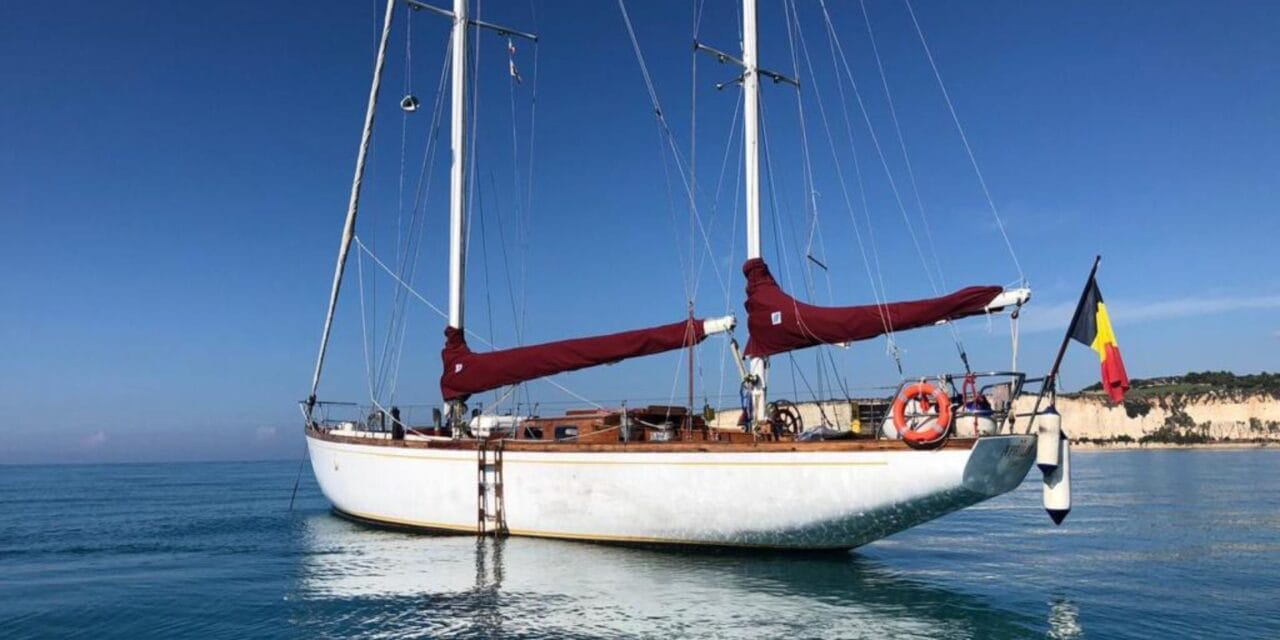
Sailing Across the Atlantic: A Guide for Fellow Sailors
Sailing across Atlantic is a journey that has captivated sailors for centuries. It’s a true test of seamanship, resilience, and the unquenchable thirst for adventure that drives us to the open ocean. Whether you’re charting a course from the Canary Islands to the Caribbean or setting sail from New York to Ireland, preparation is key. Having crossed the Atlantic several times, I’d like to share some insights with statistics and opinions, to help you prepare for this remarkable voyage and Build your Blue Ocean Miles
Introduction to Atlantic Crossing by Sailboat
The ocean becomes your world during an Atlantic crossing. Days blur together as you sync with the sea’s endless rhythm, while each wave and weather change tests what you’re made of. It’s nothing like a typical sailing trip – out here, you’re truly living with the ocean, not just traveling across it. Each route offers its own set of conditions and experiences:
- Northern Route: Ideal for eastward crossings, utilizing the prevailing westerlies and Gulf Stream.
- Southern Route: Favored for westward journeys, harnessing the dependable trade winds and Ocean West-flowing current.
- Mid-Latitude Route: A middle path balancing distance and weather conditions.
Some statistics
Approximately 1,500 to 2,500 sailboats make the transatlantic crossing each year. The majority are recreational sailors seeking adventure, with a significant number joining organized rallies like the Atlantic Rally for Cruisers (ARC).
Anecdote: A Tale of Two Crossings
I recall my first crossing in the early 2000s, sailing a 40-foot sloop from the Canary Islands to Barbados. We faced consistent trade winds, and the journey was a sailor’s dream—sunny days, star-filled nights, and the steady hum of the sea. Contrast that with a later eastbound trip from Bermuda to the Azores, where we dodged low-pressure systems and contended with fickle winds. Each crossing is unique, teaching us new lessons about the ocean and ourselves.

Best Time for Westward Crossing
Optimal Timing
For westbound sailors, the sweet spot is late November to early December. This timing ensures you’re capitalizing on the trade winds while avoiding the tail end of the hurricane season. Climate is warming so my private advise is: start later. Don’t start too early.
Benefits
- Steady Trade Winds: The Northeast Trade Winds are well-established, typically blowing 15-20 knots. Expect 25-33 knots
- Predictable Weather: Reduced likelihood of tropical storms. But risk always exists! So, you’ll need updated forecasts.
- Fleet Support: Many sailors depart during this window, offering mutual support. Sail Tenerife or Canaria and ask in the bar 🙂
Statistics
- Average Crossing Time: For a 40-50 foot cruising yacht, expect 16 to 21 days to reach the Caribbean.
- Participation Numbers: The ARC typically sees over 200 yachts each year, with sailors from over 30 countries.
Case Study: The 2019 ARC Crossing
In 2019, the ARC fleet experienced particularly favorable conditions. The fastest monohull completed the crossing in just 11 days, while the average was around 18 days. Participants reported consistent trade winds and minimal squalls.
Ideal Season for Eastward Crossing
Optimal Timing
When heading east, aim for May to June. This period offers stable weather and the benefit of the prevailing westerlies without the risk of early tropical storms. Starting before you will sail across cold and windy North atlantic. Starting too late you can meet North-going hurricane. So, window is narrow.
Benefits
- Prevailing Westerlies: Winds from the west averaging 15-25 knots, ideal for an eastbound passage.
- Calmer Seas: Before the North Atlantic storm season ramps up.
- Long Days: Extended daylight help with navigation and boosts morale.
Statistics
- Average Crossing Time: From the Caribbean to the Azores is about 15 to 20 days, with an additional 7 to 10 days to reach mainland Europe.
- Common Routes: Approximately 60% of eastbound sailors stop in the Azores.
Expert Opinion: Jimmy Cornell
Jimmy Cornell notes, “Departing in May reduces the likelihood of encountering the harsh spring storms that can sweep across the North Atlantic. It’s the best compromise between favorable winds and manageable weather.”

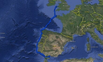
Popular Atlantic Sailing Routes
Westward Routes
Read more in post: Atlantic crossing from East to West
Canary Islands to the Caribbean
- Distance: Approximately 2,700 nautical miles.
- Highlights:
- Steady trade winds.
- Warm temperatures.
- Well-trodden route with plenty of fellow sailors.
Anecdote: The Flying Fish Highway
Sailors often refer to this route as the “Flying Fish Highway” due to the abundance of flying fish that glide over the waves. I remember waking up one morning to find dozens of them on deck—a quirky reminder of the lively ocean life around us.
Cape Verde to the Caribbean
- Distance: About 2,100 nautical miles.
- Advantages:
- Stronger trade winds can shave time off the passage. Often wide no-wind zones.
- Rich cultural experience in Cape Verde. Good place to drop an anchor for a week or two.
- Statistics:
- Some sailors report crossing times as fast as 12 days due to stronger winds.
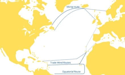
Scotland to Canada – Viking route
- Distance: Roughly 1,800 nautical miles.
- Challenges:
- Cold temperatures.
- Icebergs and fog near Newfoundland.
- Strong currents
- Historical Note: This route follows the path of Viking explorers like Leif Erikson, who sailed these waters over a millennium ago.

Eastward Routes
Read more in post: Atlantic crossing from West to East
Caribbean to Europe via Bermuda
- Distance:
- Caribbean to Bermuda: 850 nautical miles.
- Bermuda to Azores: 1,800 nautical miles.
- Azores to Europe: 1,200 nautical miles.
- Advantages:
- Breaks the journey into manageable legs.
- Opportunity to explore diverse islands.
- Statistics:
- Over 150 yachts make this passage annually. Not so many :/
Bermuda to Portugal or the UK
- Distance: Approximately 2,700 nautical miles.
- Considerations:
- Need to navigate around the Azores High to avoid calms.
- Expert Tip: Sail north of 38°N to find stronger westerlies.
Anecdote: The Azores High Dilemma
During one crossing, we got caught in the middle of the Azores High. For three days, we bobbed in glassy seas, our sails flapping uselessly. It was a stark lesson in the importance of routing and the patience required at sea. Happens too often 🙂
New York to Ireland and Scotland
- Distance: Around 3,000 nautical miles.
- Features:
- Benefit from the Gulf Stream’s warmth and speed.
- Statistics:
- The Gulf Stream can increase speed over ground by 2-4 knots.
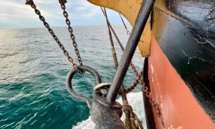
Essential Gear and Equipment
Navigation Tools
- GPS Systems: Dual systems recommended for redundancy. Tip: you have it in your phone 🙂 But need to charge.
- Paper Charts: Essential backup; electronics can fail.
- Autopilot and Windvane: Both are invaluable—autopilot for convenience, windvane for reliability without power consumption.
- Some traditional Navigational Instruments, like sextant. But don’t forget tables 🙂
Anecdote: When Electronics Fail
On one trip, our primary GPS failed mid-Atlantic. Thanks to our backup handheld GPS and celestial navigation skills, we stayed on course. It’s a sobering reminder that technology can fail when you need it most. So be prepare and learn how to use a sextant properly. It’ll not help you sailing between reefs but you can hit a target country, at least 🙂 More in blog Old Navigational Instruments for Sailors and How They Worked
Communication Devices
- VHF Radio: For ship-to-ship and ship-to-shore within line of sight. You will probably see few vessels only
- SSB Radio: Allows for long-distance communication and participation in nets like the Cruisers’ Net.
- Satellite Phone: Provides global coverage for emergencies and weather updates.
- STARLINK: perfect satelite solution to have Internet onboard
- AIS (Automatic Identification System): Enhances safety by identifying nearby vessels.
Safety Gear
- Life Raft: Ensure it’s in date and serviced. Consider a model with a canopy and insulated floor.
- EPIRB: Register it before departure; it could save your life.
- Personal Locator Beacons (PLBs): Useful for individual crew members.
- Flares and Signal Devices: Check expiry dates and storage conditions.
- First Aid Kit: Tailor it to your crew’s needs; consider seasickness remedies, antibiotics, and pain relievers.
Expert Opinion: Lin and Larry Pardey
The Pardeys advise, “Your safety gear is only as good as your ability to use it. Regular drills and familiarity with equipment can make all the difference in an emergency.”

Life Onboard During the Crossing
Daily Routines and Duties
- Watch Systems: Common rotations are 3 hours on, 6 hours off or 4 hours on, 8 hours off.
- Maintenance: Daily checks of rigging, sails, and equipment. I do that twice: after dawn and before dusk.
- Log Keeping: Record position, weather conditions, sail configurations, and any notable events.
Meal Preparation and Cleaning
- Provisioning Tips:
- Stock up on durable fruits like apples and oranges.
- Vacuum-sealed meats can last longer.
- Canned goods are reliable staples. Unless you lose opener 🙂
- Water Consumption:
- Average of 3-4 liters per person per day for drinking and cooking. I calculate 4 L pp.
- Solar showers are a boon for conserving freshwater.
- Drink water and check your crew to avoid dehydrating, especially in law altitudes.
Anecdote: The Bread-Baking Tradition
Many sailors, myself included, bake bread onboard. There’s something comforting about the smell of fresh bread wafting through the cabin. It also boosts morale and provides a delicious staple. When you have this skill – you are crew’s best friend 🙂 Note: I couldn’t find a black cumin, last year in Tenerife.
Leisure and Relaxation
- Reading and Journaling: A perfect time to catch up on books or keep a detailed journal.
- Fishing: Trolling a line can yield mahi-mahi or tuna.
- Music: Sharing songs or playing instruments lifts spirits.
Wildlife and Scenic Views
- Marine Life Sightings:
- Dolphins: Often ride the bow wave, a joyful sight.
- Whales: Keep a respectful distance; they can be unpredictable.
- Sea Turtles: Occasionally spotted basking at the surface.
- Night Sky:
- With minimal light pollution, the Milky Way is breathtaking.
- Look out for meteor showers like the Geminids in December.
Anecdote: The Night of Bioluminescence
One moonless night, our wake glowed with bioluminescent plankton. Every disturbance in the water ignited with light, making it feel like we were sailing through stars.
Weather Patterns and Forecasts
Understanding the Trade Winds
- Latitude Range: Between 10°N and 25°N.
- Consistency: More reliable in winter months.
- Weather Phenomena: Be prepared for squalls—short, intense bursts of wind and rain.
Navigating the Westerlies
- Latitude Range: Between 35°N and 65°N.
- Weather Systems: Monitor for depressions and frontal systems.
- Routing: Weather routers can help optimize your path.
Navigating the Easterlies
- Intertropical Convergence Zone (ITCZ):
- Known as the doldrums.
- Characterized by calms and thunderstorms.
- Cross it quickly if your route requires.
Impact of Seasonal Variations
- Winter Crossings:
- North Atlantic storms can produce waves over 10 meters.
- Requires a sturdy vessel and experienced crew.
- Summer Crossings:
- Summer season demands vigilant hurricane’s monitoring.
- Invest in reliable weather forecasting services.
Expert Opinion: Bob McDavitt, Weather Guru
Bob emphasizes, “Understanding the ‘why’ behind weather patterns is as important as the ‘what.’ It empowers you to make better decisions at sea.”
Safety Measures and Precautions
Vessel Readiness
- Hull and Rigging:
- Inspect for any signs of wear or damage.
- Replace standing rigging if it’s over 10 years old or shows wear.
- Engine:
- Service before departure.
- Carry spare parts like filters, belts, and impellers.
- Sails:
- Have sails inspected.
- Consider carrying a storm jib and trysail.
Crew Preparedness
- Training:
- Ensure all crew can reef sails, handle lines, and operate safety equipment.
- Health:
- Obtain necessary vaccinations.
- Carry personal medications and spares.
Emergency Protocols
- Man-Overboard (MOB):
- Practice drills.
- Use jacklines and harnesses, especially at night or in rough conditions.
- Never pee overboard 🙂 It’s one of the common causes of falling overboard.
- Fire Safety:
- Know the location and operation of extinguishers.
- Abandon Ship:
- Ditch bag should be prepared with essentials.
Case Study: 2015 Mid-Atlantic Rescue
A yacht en route to the Caribbean struck a submerged object and began taking on water. Thanks to their EPIRB and coordinated efforts with nearby vessels and rescue services, the crew was safely evacuated. Their preparedness and adherence to safety protocols were crucial.
Tips for a Successful sailing across Atlantic
Energy Management
- Power Generation:
- Solar panels are quiet and efficient.
- Wind generators complement solar, especially at night.
- Consumption:
- LED lighting reduces energy use.
- Be mindful of autopilot and refrigeration draw.
- TIP: I turn an engine twice a day for one hour. Never any problems with low energy level.
Handling Adverse Weather
- Reef Early:
- A common sailor’s adage: “If you think about reefing, do it.”
- Sail Configurations:
- Downwind sailing may benefit from poled-out headsails.
- Heaving To:
- Practice this technique before you need it.
Using the Engine When Necessary
- Fuel Calculations:
- Plan for at least 100 hours of motoring.
- Take some additional cans of fuel. If too much – you can use it later.
- Maintenance:
- Check oil and coolant levels regularly.
- Check batteries often
- Twice a day make a walk on deck and check everything, like pins, clasps, ropes, shackles, screws
Anecdote: The Engine That Saved the Day
Winter 2024. On a calm crossing, we faced a week windless stretch. Our engine kept us moving, but fuel was dwindling. And we had airplane tickets to ketch last plane from barbados and spend Christmas at home. We rigged all sails we had, which helped conserve fuel.
Most popular routes after or before your Atlantic crossic are in separate posts:
- Crossing Bay of Biscay by Sailboat – few words how to cross Bay of Biscay
- Sailing from UK to the Mediterranean and Back – one of our most popular routes
- Sailing in Gibraltar – How to cross the Strait of Gibraltar? – how and when to cross Gibraltar Strait
- Atlantic crossing from West to East – some details about West to East crossing
- Atlantic crossing from East to West – details regarding East to West Atlantic routes
Conclusion
Sailing across the Atlantic is more than a voyage; it’s an odyssey that challenges and enriches us. The ocean teaches humility and patience, rewards preparation, and offers moments of unparalleled beauty.
Key Takeaways
- Preparation is Paramount: From vessel maintenance to crew training, leave nothing to chance.
- Respect the Sea: Weather can be unpredictable; stay vigilant and adaptable.
- Avoid hurricanes – learn how they works, what to expect and how to avid them
- Weather Patterns and data files you get are important. Understand Grib files and Forecast models
- Embrace the Experience: Every day brings new sights and lessons.
- Community Matters: Fellow sailors are a valuable resource—share knowledge and stories.
As sailors, we’re part of a lineage of explorers and adventurers. Each crossing adds to that legacy. So, chart your course, prepare diligently, and set sail with confidence.
Fair winds and following seas to all who venture across the Atlantic !!!
