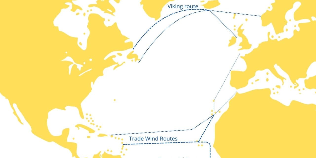
Transatlantic Crossing from East to West: 3 Different Routes
Sailing across Atlantic from East to West is a significant maritime endeavor that has been undertaken by sailors for centuries. The journey requires careful planning, knowledge of weather patterns, and an understanding of the various routes available. This short guide shows the different routes, providing relevant facts, statistics, case studies, and expert opinions to aid sailors in making informed decisions.

Main Routes for East-to-West Atlantic Crossing
1. Northern “Viking” Route (Great Circle Route)

- Description: The Northern Route is the shortest distance between Europe and North America, following a great circle path at higher latitudes.
- Starting Points: Typically from the British Isles, France, or Northern Europe.
- Ending Points: Eastern seaboard of the United States or Canada.
Characteristics:

- Distance: Approximately 2,800 nautical miles (varies based on exact departure and arrival points).
- Weather Conditions: More challenging due to variable weather, including strong westerly winds, fog, and the potential for severe storms.
- Sea Conditions: Rougher seas with higher risk of encountering icebergs, especially near Newfoundland.
Statistics:
- Duration: 15–25 days, depending on vessel speed and weather conditions.
- Usage: Less popular among recreational sailors due to harsher conditions; preferred by commercial vessels and experienced sailors.
Considerations:
- Best attempted during the summer months (June to August) when conditions are milder.
- Requires a well-prepared vessel and experienced crew!!!
2. Southern Route (Trade Wind Route)

- Description: The Southern Route leverages the northeast trade winds and favorable currents, making it the most popular route for east-to-west crossings.
- Starting Points: Canary Islands, Cape Verde Islands, or the coast of West Africa.
- Ending Points: Caribbean islands, such as St. Lucia, Antigua, or Barbados.
Characteristics:
- Distance: Approximately 2,700–3,000 nautical miles.
- Weather Conditions: Generally consistent trade winds (15–25 knots) and warm temperatures.
- Sea Conditions: Moderate seas with long ocean swells.
Statistics:
- Duration: 18–21 days for a 40-foot cruising yacht.
- Usage: Most popular route among cruising sailors and participants in organized rallies.
Considerations:
- Optimal departure window is from late November to early January to avoid the Atlantic hurricane season.
- Offers a more comfortable and predictable passage compared to the Northern Route.
3. Equatorial Route

- Description: A less common route that involves crossing near the equator, often used when sailing from West Africa to South America.
- Starting Points: Countries like Senegal or the Cape Verde Islands.
- Ending Points: Northeastern coast of South America, such as Brazil.
Characteristics:
- Distance: Varies greatly depending on departure and arrival points.
- Weather Conditions: Light and variable winds near the equator, with a risk of calms in the Doldrums (Intertropical Convergence Zone).
- Sea Conditions: Generally calmer seas but with the potential for sudden squalls.
Statistics:
- Duration: Longer passage times due to variable winds; can exceed 30 days.
- Usage: Less frequented by recreational sailors; more common among yachts circumnavigating the globe.
Considerations:
- Requires careful planning to navigate the Doldrums efficiently.
- Adequate fuel reserves are essential due to the possibility of extended periods without wind.
Weather Patterns and Ocean Currents
Trade Winds

- Northeast Trade Winds: Prevail between 5° and 25° N latitude, blowing from the northeast to the southwest.
- Southeast Trade Winds: Found in the southern hemisphere, affecting routes closer to the equator.
Ocean Currents
- Canary Current: Flows southward along the northwest coast of Africa, aiding departures from the Canary Islands.
- North Equatorial Current: Moves westward across the Atlantic, assisting vessels on the Southern Route.
Seasonal Considerations
- Hurricane Season: Runs from June 1 to November 30 in the North Atlantic.
- Optimal Sailing Window: Late November to early January for the Southern Route to avoid hurricanes and benefit from favorable winds.
Case Studies
Atlantic Rally for Cruisers (ARC)
- Overview: An annual transatlantic sailing event organized by the World Cruising Club.
- Route: From Las Palmas de Gran Canaria to Rodney Bay, Saint Lucia.
- Participation:
- 2022 Edition: Over 200 yachts from more than 30 countries.
- Participants: A mix of experienced sailors and families embarking on their first ocean crossing.
- Purpose: To provide a structured and supportive environment for sailors crossing the Atlantic.
Insights:
- Safety in Numbers: Participants benefit from shared knowledge and mutual assistance.
- Camaraderie: Social events and radio nets foster a sense of community.
Notable Solo Voyages
Dame Ellen MacArthur
- Achievement: Set the world record for the fastest solo circumnavigation in 2005.
- Route: Included a challenging east-to-west Atlantic crossing.
- Lessons Learned:
- Importance of mental resilience and meticulous preparation.
- Dealing with unpredictable weather and equipment failures.
Expert Opinions
Jimmy Cornell (Author of “World Cruising Routes”)
- Advice:
- Recommends the Southern Route for its favorable trade winds and safer weather conditions.
- Emphasizes the importance of departing at the right time to maximize wind benefits and minimize risks.
- Preparation Tips:
- Thoroughly inspect the vessel and equipment before departure.
- Stay updated on weather forecasts and be prepared to adjust plans accordingly.
Chris Tibbs (Meteorologist and Sailing Expert)
- Insights on Weather:
- Highlights the impact of the Azores High on Atlantic weather patterns.
- Advises sailors to monitor the position and strength of the high-pressure system for optimal routing.
- Routing Recommendations:
- Suggests a southerly course initially to avoid calms near the high-pressure zone.
- Recommends utilizing weather routing services for real-time guidance.
Safety Considerations

- Vessel Readiness:
- Ensure all safety equipment is up to date (life rafts, EPIRBs, flares).
- Install reliable communication systems (satellite phone, AIS).
- Crew Preparedness:
- Conduct safety drills and establish watch rotations.
- Ensure all crew members are trained in first aid and emergency procedures.
- Emergency Protocols:
- Develop a clear plan for man-overboard situations.
- Maintain regular check-ins with a designated contact onshore.
Environmental and Regulatory Factors
- Ballast Water Management:
- Comply with international regulations to prevent the spread of invasive species.
- Marine Protected Areas (MPAs):
- Be aware of MPAs along the route and adhere to restrictions to protect marine life.
- Waste Management:
- Implement a zero-waste policy where possible.
- Dispose of waste responsibly at designated facilities upon arrival.
Statistics on Atlantic Crossings
- Annual Crossings:
- An estimated 1,000–2,000 recreational yachts make the east-to-west Atlantic crossing each year.
- The majority choose the Southern Route due to its favorable conditions.
- Success Rates:
- High success rates among well-prepared crews.
- Incidents are relatively rare but can include mechanical failures and medical emergencies.
Technological Advancements
- Navigation Tools:
- GPS and electronic chart plotters enhance safety and ease of navigation.
- AIS technology allows for better tracking of nearby vessels.
- Weather Forecasting:
- Access to detailed weather models and forecasting services aids in route planning.
- Satellite communications enable real-time updates.
Popular routes before you heading West are in below posts:
- Crossing Bay of Biscay by Sailboat – few words how to cross Bay of Biscay
- Sailing Across the Atlantic: A Comprehensive Guide for Fellow Sailors – read it before your first Atlantic passage
- Sailing in Gibraltar – How to cross the Strait of Gibraltar? – how and when to cross Gibraltar Stait
- Sailing from UK to the Mediterranean – some datails about West to East crossing
- Atlantic crossing from West to East – details regarding popular West to East Atlantic routes
Conclusion
Sailing across the Atlantic from East to West offers a variety of routes tailored to different preferences and experience levels. The Southern Route remains the most popular among recreational sailors due to its favorable winds and predictable weather patterns. The Northern and Equatorial Routes present additional challenges and are typically chosen by more experienced sailors or those with specific destinations. Every option will help you Build your Ocean Miles
Key Takeaways:
- Preparation is Crucial: Thorough planning and vessel readiness significantly increase the chances of a successful crossing.
- Timing Matters: Departing within the optimal weather window minimizes risks associated with adverse weather.
- Expert Guidance: Leveraging the knowledge of experienced sailors and meteorologists can enhance safety and efficiency.
Embarking on an Atlantic crossing is a rewarding experience that combines the thrill of adventure with the satisfaction of meticulous planning and seamanship. By understanding the nuances of each route and heeding expert advice, sailors can navigate the vast Atlantic Ocean with confidence.


